
All Posts By

SFDP-admin

PIA15+HRIGI15 – Call for papers – Full paper deadline: NOV-30

Dear Colleague,

Let me kindly inform you that the conference chairs of PIA15+HRIGI15 cordially invites you to submit a paper to the joint ISPRS event:

  • PIA15 – Photogrammetric Image Analysis
  • HRIGI15 – High resolution Earth Imaging for Geospatial Information

Munich, Germany – March 25-27, 2015
http://www.pia15.tum.de
Call for Papers:

Automated extraction of objects from remotely sensed data is an important topic of research in Computer Vision, Photogrammetry, Remote Sensing, and Geoinformation Science. In order to discuss recent developments and future trends in research in automatic object extraction and their influence on sensors and processing techniques, the two well known ISPRS workshops “Photogrammetric Image Analysis” (PIA) and “High resolution earth imaging for geospatial information” (HRIGI, also known as the ISPRS-Hannover Workshop) will be held as a common event for the first time.
The location of the event will be Munich, Germany.

Scope:

While in the past PIA specialised on the automatic exploitation of the image content, the strongest side of HRIGI was the geometric processing of aerial and in particular of space imagery. Realising that both areas – geometry and semantics – can significantly support each other when considered together in photogrammetric image exploitation, the two events will be organised under a common roof held at Technische Universitaet Muenchen (TUM) in March 2015.
At the same time they will keep their identity, as the meeting will be organised as two parallel workshops with common plenary sessions and common proceedings.

The aim of the common event is to seek, exploit and deepen the synergies between geometry and semantics, and to give the two scientific communities the possibility to discuss with and to learn from each other. The joint event addresses experts from research, government, and private industry. It consists of high quality papers, and provides an international forum for discussion of leading research and technological developments as well as applications in the field.

Conference topics:

  • Small satellites and satellite constellations for mapping
  • Exploitation of high resolution space images
  • UAVs and other platforms
  • High-resolution Synthetic Aperture Radar (SAR) from air and space
  • Hyperspectral imaging
  • Sensor and system calibration and integration
  • Surface modeling and reconstruction
  • 3d object extraction: buildings, roads, vegetation
  • Learning and statistical methods for object extraction
  • Sensor and data fusion including information from GIS, BIM, or CAD
  • Image analysis for geospatial data update and change detection
  • Global landcover and landuse mapping
  • Rapid mapping for environmental applications and disaster management
  • Industrial applications

Further topics relevant for the conference can be found in the
Terms of Reference (ToR) of the cooperating ISPRS working groups:


– I/2:   http://www2.isprs.org/commissions/comm1/wg2.html
– I/4:   http://www2.isprs.org/commissions/comm1/wg4.html
– III/1:   http://www2.isprs.org/commissions/comm3/wg1.html
– III/4:   http://www2.isprs.org/commissions/comm3/wg4.html
– IV/1:   http://www2.isprs.org/commissions/comm4/wg1.html
– VII/2:   http://www2.isprs.org/commissions/comm7/wg2.html
– III/VII:   http://www2.isprs.org/commissions/comm3/icwg37.html

Paper Submission:

Prospective Authors are encouraged to submit either full papers or abstracts.


Full paper of maximum 8 pages will undergo a rigorous double blind peer review process. Accepted papers will be published in “ISPRS Annals of the Photogrammetry, Remote Sensing and Spatial Information Sciences”. The fact that the full papers were peer reviewed will be mentioend on each paper. The series was newly established in 2012.

Alternatively, authors may submit an extended abstract of about 1000 words. In case of acceptance by the program committee, these authors are invited to submit a full paper which will be published in “The International Archives of the Photogrammetry, Remote Sensing and Spatial Information Sciences”.

The type of presentation (oral or interactive) will be decided by the program committee and will be dependent upon the subject of the paper and the way it fits to the overall program.

The Archives and the Annals will be available as open access papers and will submitted  to Thomson Reuters’ for inclusion into the Conference Citation Proceedings Index (CPCI), one of the indices of the Web of Science. They are also listed in SCOPUS.

Conference Venue:

The conference will be held in Munich, the capital of Bavaria, and will be hosted by the Chair of Photogrammetry and Remote Sensing, Technische Universitaet Muenchen (TUM). The workshop site is located at TUM, close to the museum district, and in walking distance to the main station and center of Munich.

Important dates:

 – Submission of full papers  November 30, 2014
 – Abstract deadline  November 30, 2014
 – Notification of authors  January  15, 2015
 – Submission of camera ready manuscripts  February 10, 2015
 – Author registration deadline  February 10, 2015
 – PIA15 + HRIGI15  March 25-27, 2015

 
Coordination with JURSE 2015:

We are coordinating our event with the JURSE 2015 conference held in Lausanne March 30 – April 01, 2015 http://jurse2015.org/ For authors planning to attend both PIA+HRIGI and JURSE, papers accepted for inclusion in the PIA+HRIGI conference will be offered a poster spotlight during JURSE. The paper will be reviewed only by the PIA+HRIGI program committee and will appear only in the
PIA+HRIGI proceedings. This is an opportunity on a voluntary base.

We apologize for any cross-postings.

U. Stilla and C. Heipke
Web Seminar Invitation: Do you speak Digital?


Web Seminar Invitation / Do you speak Digital?
 
For aerial acquisition companies that still operate exclusively with film sensors, the digital arena can seem like a different world with its own language. Many film flyers approach discussions about migrating from their film systems to digital systems with concerns over differences in base-to-height ratio, focal lengths and concepts such as scale versus ground sample distance.


This 45-minute webinar discusses the aspects of aerial data acquisition that must be considered when replacing more traditional analog approaches with those based on newer digital technologies. The discussion covers data collection as well as post-processing, and focuses on Microsoft UltraCam hardware and software systems. Come armed with your questions for the Q&A that will follow the presentation. Better yet, send your questions to ensure they are addressed during the presentation: ultracam@microsoft.com.


Presenters:

Alexander Wiechert, Business Manager

Michael Gruber, Chief Scientist


Who should attend:

Aerial mapping companies, Departments of Transportation, Surveyors, Photogrammetrists, organizations planning for digital camera operation and production.


Register Today!


Click on the link below that corresponds to your preferred date and time to add a live meeting reminder to your Outlook calendar.


For attendees in Europe and the eastern time zones such as Russia, Asia Pacific, China, Australia, New Zealand:
December 2, 7 am GMT (8am Central European Time)


For attendees in the western time zones such as USA, Canada, Latin America:

December 2, 3 pm GMT (10am Eastern Daylight Time)


DETAILS for December 2, 7am GMT Live Meeting:


Please note that you will not be able to join until 30 minutes prior to the scheduled meeting start time.


Webinar URL: https://www.livemeeting.com/cc/microsoft/join?id=BQP6D6&role=attend&pw=6-Jd%7BgS%3AW OR https://www.livemeeting.com/cc/microsoft/join and enter the information below


Meeting ID: BQP6D6
Entry Code: 6-Jd{gS:W

Location: https://www.livemeeting.com/cc/microsoft


DETAILS for December 2, 3:00 pm GMT Live Meeting:


Please note that you will not be able to join until 30 minutes prior to the scheduled meeting start time.


Webinar URL: https://www.livemeeting.com/cc/microsoft/join?id=2NQ4RD&role=attend&pw=5FT%7BJhp%25r OR https://www.livemeeting.com/cc/microsoft/join and enter the information below


Meeting ID: 2NQ4RD
Entry Code: 5FT{Jhp%r
Location: https://www.livemeeting.com/cc/microsoft


GENERAL Webinar Information:


Audio Details:


Computer Audio (Recommended):

To use computer audio, you need speakers or a headset.


Telephone conferencing:

Choose one of the following:

*  Start Office Live Meeting client, and then in Voice & Video click Join Conference.
The conferencing service will call you at the number you specify.

*   Use the information below to connect:

Toll-free (within US only):      +1 (866) 500-6738

        Toll/International Callers:       +1 (203) 480-8000

Participant code:     2885466


First Time Users:
To save time before the meeting, check your system to make sure it is ready to use Microsoft Office Live Meeting.


Troubleshooting:

If you cannot enter the meeting, contact support.


Notice:
Microsoft Office Live Meeting can be used to record meetings. By participating in this meeting, you agree that your communications may be monitored or recorded at any time during the meeting.

 
With warm regards,
Silke KEMMER
Marketing & Quality Manager | Microsoft UltraCam Business Unit

direct +43 316 84 90 66 966| mobile +43 664 1927 966 | fax + 43 316 84 90 66 999

Vexcel Imaging GmbH, Anzengrubergasse 8, 8010 Graz, Austria

 Follow Us on Twitter  Join Us on Facebook  UltraCam Blog See UltraCam Videos

http://www.microsoft.com/ultracam 

Commercial registry number: FN 234336m, Regional court Graz


Disclaimer:

This message is intended only for the recipient(s) named above. It is confidential and may well also be legally privileged. If you have received it in error, you are on notice of its status. Any unauthorised disclosure, use or dissemination, either in whole or in part, of this message is prohibited. To do so could be a breach of confidence. Please notify us immediately by reply e-mail and then delete this message (including any attachments) from your system. This e-mail message shall not be construed as legally binding on Microsoft/Vexcel Imaging GmbH. Any Opinions, conclusions and other information expressed in this message are not endorsed by Vexcel Imaging GmbH unless explicitly indicated otherwise by an authorized representative. Any information or statements contained in this e-mail do not contain any legally binding character with regard to any agreements you may have with Vexcel Imaging GmbH and they may not be used for interpretation purposes of such agreements. Validly entered agreement between you and respective Vexcel Imaging GmbH are the only documents containing legally binding character with regard to respective contracts. Kindly note that as an employee of Microsoft/Vexcel Imaging GmbH (without signatory power) I am not authorized to enter any agreements on behalf of Microsoft/Vexcel Imaging GmbH. Thank you for your cooperation!

© 2014, Microsoft Corp. All rights reserved. Microsoft, Vexcel Imaging GmbH, UltraCam and UltraMap are either registered trademarks or trademarks of Microsoft Corporation in the United States and/or other countries.

  Unsubscribe


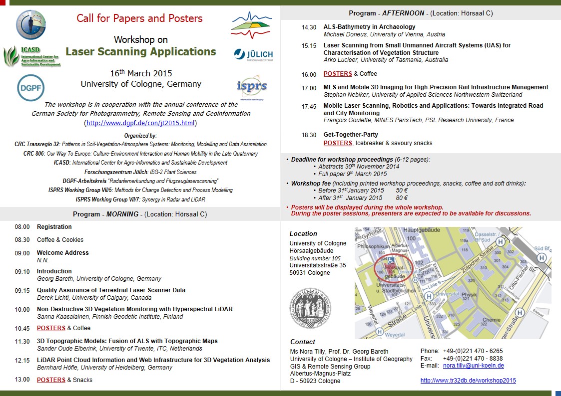
1st Call: Workshop on Laser Scanning Applications

Dear Colleagues,

I would like to draw your attention on our Workshop on Laser Scanning
Applications which we will organize in Cologne on March 16th, 2015.

Please find attached the preliminary program and the call for posters.

Our workshop is organized in cooperation with the annual conference of the
German Society for Photogrammetry, Remote Sensing and Geoinformation
(http://www.dgpf.de/con/jt2015.html).

Sorry for cross-postings.

Sincerely,
Georg Bareth
*******************************
Prof. Dr. Georg Bareth
Geography, GIS & RS
University of Cologne
50923 Cologne
++49-221-470-6552 Fax: -1638
g.bareth@uni-koeln.de
www.geographie.uni-koeln.de/gis


laser_scanning_aplications






